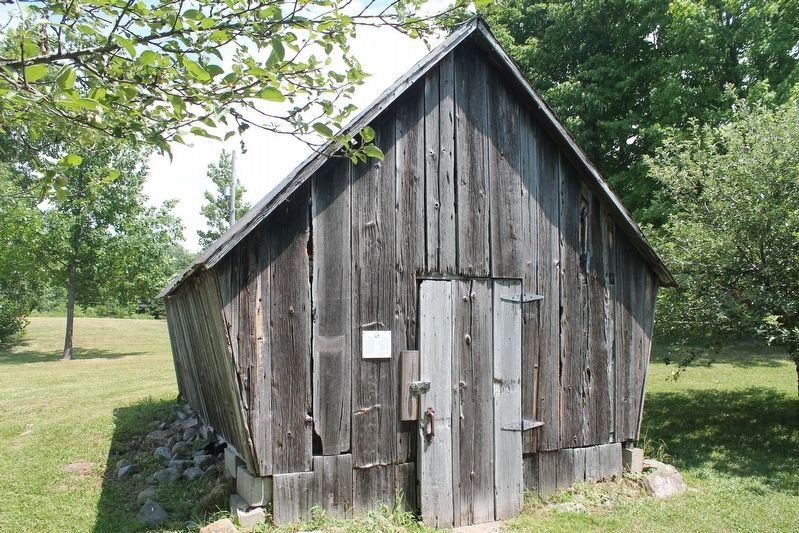
Corn Crib
The sides of the corn crib were
covered in slats to allow ventilation
for the corn to dry. The slanted
sides allowed the water to fall
from the roof and not bounce up
on the sides of the building. If the
corn became . . . — — Map (db m202442) HM
To the south-west, at approximately two kilometers, lies Dickinson's Landing, a stagecoach stop on the mail line between Montreal and Kingston, operated by Barnabus Dickinson, the village's founder. The construction of the Cornwall Canal . . . — — Map (db m205337) HM
The blacksmith shop is in much the
same condition as it was when found
at the McDonald farm, located on the
Service Road, east of the intersection
of Highway 401 and McConnell Avenue,
Cornwall.
Flora (Grant) Dumouchel, . . . — — Map (db m202392) HM
Forbes Memorial Reading Room
Originally built as a Reading Room
(Library) in 1901, the Forbes Memorial
Reading Room was a gift to the
community of Newington by George C.
Forbes, in honour of his mother, Isabella
(Mrs. Peter) . . . — — Map (db m202570) HM
On July 1, 1958, Lake St. Lawrence was created. Under it's majestic waters, now lie the six "Lost Villages" of Mille Roche, Moulinette, Dickinson's Landing, Wales, Farran's Point and Aultsville. This large body of water embodies . . . — — Map (db m205335) HM
Macleod Log House
This building was moved to Ault Park in
1974, under the supervision of the late
John Brownell, a charter member of
the Lost Villages Historical Society. He
was instrumental in locating it on the
Norman . . . — — Map (db m202454) HM
Manson/Lapierre General Store
This building was originally part of a
barn at Mille Roches. Howard Manson
moved it to a central location in Mille
Roches, and he converted it into a store.
The deep windowsills and the . . . — — Map (db m202447) HM
To the south-east, at approximately one-half kilometre, lies Mille Roches, once a village of 900 residents. Between 1890 and 1910, much quarrying took place near the village. The stone was used for the rebuilding of the Cornwall Canal and Lock . . . — — Map (db m205345) HM
To the south at approximately one-half kilometre, lies Moulinette, once a village of 300 residence. Adam Dixson, of Moulinette's prominent family, built the first dam across to Sheek Island and part of the Cornwall Canal, near the village. Christ . . . — — Map (db m205346) HM
This Grand Trunk/Canadian National Railroad Station was once located at Moulinette, Ontario. (About ½ mile southwest of this location) It was through the efforts of John G. Snetsinger, a member of Parliament for Stormont from 1896-1900 and an . . . — — Map (db m151268) HM
S.S. #17 - Roxborough Township School
This school was opened as a museum on July 1, 2000, as the Lost Villages
Historical Society's Millennium project. Alice Ferguson, (last principal) and Hazel
Grant (former teacher) . . . — — Map (db m202499) HM
Sandtown Advent Christian Church
The Sandtown Advent Christian
Church did not come from a "lost
village", but instead came from the
Township of Osnabruck. Originally built
as an Orange Lodge around 1860, it was
converted to a church in . . . — — Map (db m202511) HM
The Stuart home was donated to the Lost
Villages Historical Society in early 2004
by Cheryl (Stuart) Griffith, the niece of
the late owners Donald and Wilda Stuart,
and moved to the museum site in May of
the same year. The Griffith . . . — — Map (db m202573) HM
Between this cemetery and the wooded island to the south, once lay the village of Wales. First a land grant to Dr. J Stuart, U.E.L., it became the local commercial centre, after 1856, when the railroad arrived. It was named Wales after . . . — — Map (db m205341) HM
Zina Hill Barber Shop
This barber shop was formerly located
in the village of Moulinette. A picture of
it attached to the Zina (pronounced "Zi-nee") Hill house, at its original location,
may be found in a photo inside . . . — — Map (db m202443) HM